Wadi Al Ayn Tombs
These tombs lie about 30 kilometres north-east of Bat settlement. The tower tombs are located on high rocky hills on the northern bank of the Wadi Al Ayn, where 21 tombs line up in an almost straight line. These tombs are of the same beehive style tombs as the Bat settlement and are also believed to date back to the third millennium BC. Al Ayn Tombs are built in limestone blocks. Each tomb measures 5 metres across, and they have a triangular entrance facing east.
Al Manzafah
Al Manzafah, with its forts, towers and old buildings constructed from traditional Omani plaster and cement, contains inscriptions and decorations that are looked upon as a prominent cultural landmark. Although the old town’s buildings are dilapidated, time did not destroy its landmarks, which are still a living witness to this region’s glorious past. Al Manzafah lies in Wilayt Ibra in A’Sharqiyah North Governorate.
Bayt AlQefel (the lock house)
This type of house is common in Musandam Governorate. Bayt AlQefel represents a special kind of architecture that is a testimony to the old Omanis’ ingenuity and their adaptation to the conditions of the weather and life, and how they tamed the environment to suit their needs. The house is first built by digging the earth for a depth of not less than one metre. After that, large pottery jars are placed to store dates and other staples for the harsh summer months in these mountains. Then the house is constructed with an extremely small entrance that would allow no more than one person to enter almost crawling. After that the house structure was built up from pebbles (these are mountain rocks). The roof was finally put on, usually made from the trunks of jujube, acacia or latab trees and covered with a layer of mud and stones to form an insulating layer from moisture, rain and extreme heat.
The name of this type of house comes from a special locking system. It contains two locks that give the house owner greater security, and also let him store staples at home when he left for the coast during the hot summer months.
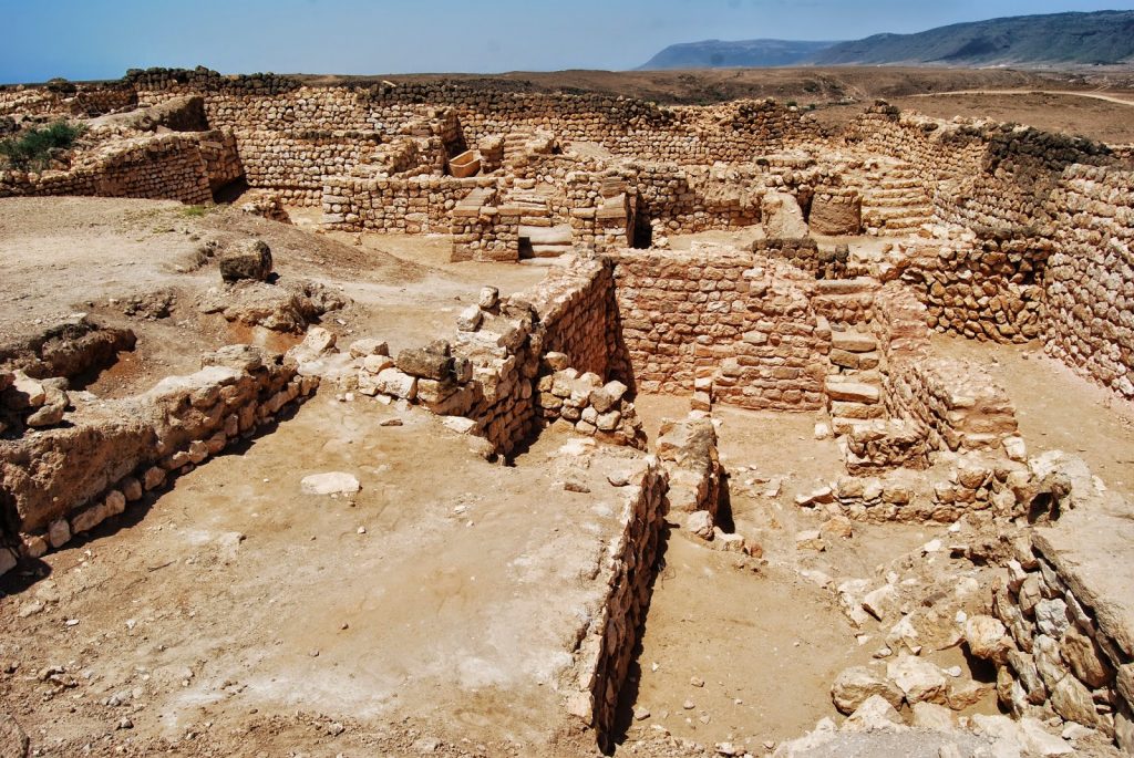
Al Balid City
The Most Important Ancient Port on the Arabian Sea (Part of the Frankincense Trail) history dates back to before 2000 BC. Some archaeological research confirms that the city’s prosperity dates back to the Iron Age. Much of this city’s remains lie in Dhofar Governorate.
The city was a trade hub, being one of the largest ports on the Indian Ocean, making it a thriving commercial centre for the export of frankincense to China and Rome. The city’s location was first discovered in 1930. Currently, the office of His Majesty the Sultan’s Adviser for Cultural Affairs is carrying out a comprehensive programme to develop the site, which is a collection of ruins covering a rectangular area of 64 hectares, surrounded by high walls to the east and north, and a small trench to the west. The wall has four gates.
The ancient city was divided into three main sections: commercial, residential and a section devoted to services. There were also a mosque and a fort on the west side. In 2000, Al Balid City was registered by UNESCO as a World Heritage Site.
Al Balid Fort: These monumental ruins represent the remains of Al Balid Fort. They tower to a height of 13 metres, with three circular towers in the corners, as well as several other semi-circular towers. The low ground in the middle of the fort is the remains of a large courtyard. It is believed that Al Balid Fort once comprised more than four storeys.
Al Madinah Wall: To the north-west of the fort lie the remnants of the ancient city wall, used for protection from the seasonal rains that flooded the mountains of Dhofar.
Bat Tombs and Settlement
Bat Tombs historical sites are located in Bat, Al Khutum and Al Ayn in A’Dhahirah Governorate in Wilayt Ibri. They are considered one of the archaeological and historical sites that date back to the third century BC and are located to the east of Ibri. In 1988, Bat Tombs was the second site to be included in the World Heritage list in Oman.
In the southern part, the site is a collection of graves built on the lines of those found in Um AnNar, while in the northern part, the graves look like beehives and date back to the third millennium BC. The architecture is similar to the tombs built in the Hafit period. Another cemetery containing 100 tombs built of stone was also discovered, where the evolution from the beehive style to cemeteries built during Um AnNar period is apparent. While the beehive cemetery contained between two to five tombs, Um AnNar cemeteries were mass graves. A similar cemetery of this style was discovered containing 30 burial chambers. The historic significance of the Bat site is that it is located at the crossroads of an ancient trade route. Caravans loaded with goods heading to other nearby destinations passed through Bat. Included with the Bat settlement in the World Heritage List are two other sites: Al Khutum “Al Wahrah” and Wadi Al Ayn Tombs.
Hasat Bin Salt
This is an ancient rock which has inscriptions and the writings that date back to the dawn of history. This rock is reminiscent of the Rosetta Stone which was discovered in Egypt. Hasat Bin Salt is located in one of the most beautiful tourist areas in Wilayt Al Hamra in A’Dakhiliyah Governorate.
Bawshar Tombs
The Tombs in Bawshar – located in Muscat Governorate- are distinguished by their circular shaped burial sites, lined with stones and covered with boulders. Researchers have put the age of these tombs at the second and first centuries BC. Many overlapping divided tombs have been found stretching to a length of 22 metres, dating back to the early Iron Age. This type of burial tombs is called honeycomb tombs.
Hafeet Site
The site is located in Al Buraymi Governorate. It is an old settlement that dates back to the third millennium BC. This site was a meeting place for trade caravans between the Bat civilisation in Wilayt of Ibri, and the Um AnNar civilisation. Tombs in this region date to the third millennium BC and are built like the bee hive tombs of the Bat civilisation. Also found was a piece of pottery similar to the pottery made during Nebuchadnezzar’s reign in Iraq.
Jabal Hareem Fossils
Jabal Hareem Fossils are located at a height of 1,600 metres above sea level in Wilayt Khasab in the Musandam Governorate. The trip on the way up in the four-wheel drive pushing through mountainous villages, prairies planted with wheat and green valleys is an adventure itself, and the visitor will want to pause on the journey to take in the enchanting views.
On Jabal Hareem’s flat summit you can examine fish fossils and shells, in addition to other fossilised marine life. The estimated geological age of the fossils is more than 250 million years when the peaks were under the sea.
Kibaykib - AlJaylah Towers
The towers are located at an altitude of 2,000 metres above sea level in A’Sharqiyah South Governorate (Eastern Region). Around 90 towers were discovered still in good condition, and this is due to the durability of construction. They attain a height of 5 metres, with a 4 metre diameter.
It is not easy to reach these towers, as they are constructed high up the mountains accessed via the Qurayyat- Sur road.
Old Muscat Gates
Comprise three main doors: Bab Al Mathaib, Bab Al Kabeer (The Big Door) and Bab Al Sagheer (The Little Door). Bab Al Mathaib is located in the western corner, below the Al Mirani Fort, and Bab Al Kabeer is located at the end of the western side of the walls and serves as the entrance to most roads leading to suburban Muscat and Mutrah City. Bab Al Sagheer lies in the mid-southern side, and is considered one of the city’s main entrances.
Qalhat & Bibi Mariam
In the past, Qalhat City has witnessed an ancient Omani civilization, being Oman’s first capital before the advent of Islam. In the thirteenth century it was the main commercial port linking Oman and abroad.
This city was once witness to a great ancient civilisation but has since slipped away from history, geography, time and place. Nature overpowered Man here and transformed the city into a pile of rocks, scattered over a wasteland, starting at the beach, to homes that fell to ruin, to crumbling citadels and walls that once fortified the city. It is said that the city fell prey to an earthquake in the fourteenth century. The Portuguese also invaded and occupied Qalhat until they were expelled in the late sixteenth century AD.
Qalhat’s history dates back to the Bronze Age, when it was a major city and the first capital of Oman. Also, due to many characteristics that augment its unique and distinctive location, and being an important city and port, it had the advantage of attracting travellers, explorers and seekers after knowledge.
The ruins of Qalhat include Bibi Mariam’s shrine (Bibi means “free”) who is said to be an elderly woman who built a mosque, while some historical sources mentioned that she was the governor of Qalhat during the reign of King Hormuz (Kotob Eddine Yamtuhin). At the shrine entrance, there is a crypt leading to underground corridors beneath the floor of the shrine.
The site is located in A’Sharqiyah South Governorate (Eastern Region)
Ras AlHadd Discoveries
Excavations in Ras AlHadd Discoveries in the Wilayt Sur in A’Sharqiyah South Governorate(Eastern Region) reveal ruins that date back to the prehistoric period in the Sultanate of Oman. The building contains three rooms for two or three houses built round a small courtyard. It is believed that some relics found in this site may date back to the days of Mesopotamian civilisation. Pieces of shell for making rings have been found, which indicates that this region was used for many crafts. A limestone incense burner was also found that dates back to approximately 2200 BC. Also found are two pieces of porphyry stones from a vessel base that dates back to the Egyptian civilisation. This indicates a cultural link between Oman and Pharaonic Egypt. Some women’s jewellery dating back to 2700 BC was also found there.
Samharam
Located in Dhofar Governorate and is known to be part of the frankincense road. The location tells the story of an ancient civilization in Dhofar, as Samharam city and its reputed port which history dates back to 1000 BC constituted a link between Dhofar and other parts of the world.
It is reported that the port acquired fame and significance since ancient history as the jars of Omani frankincense bound to (Balqees) the Queen of Sheba were loaded from Samharam Port, which is located east of (Salalah) City in the region located between Wilayt (Taqa) and (Mirbat). The area is currently called Bokhor Rori, and it is the natural course of the known Darbat waterfalls in Dhofar governorate.
The port is also known as “Moshka Port” that was prescribed in two Greek scrolls dating back to the era between the first and second centuries AD. Archeological excavations in Samharam city unearthed a number of scrolls, an old temple, coins and historical artifacts all of which indicated a close historic association with India, the countries between both rivers (Tigress and Euphrates), and the Nile river area.
Researchers date back the city of Samharam to 3000 BC.
Zakeet Tombs
These tombs are located in A’Dakhiliyah Governorate. Historians say that they date back to the third millennium BC. The Ancient Zakeet Tombs lie on a cylindrical hill overlooking the village, and consist of two walls of mountain rocks that resemble a beehive. The existence of these tombs on the hilltop led researchers to assume that the site was used as a fortress to repel invading armies.
Salut Archaeological Site
The historical significance of Salut is directly connected with the dawn of the Omani history, which first saw the light with the arrival of Arab tribes in Oman from different regions of the Arabian Peninsula. This site is witness to the beginning of settlements in Oman. Salut Archaeological Site is located on top of a rocky hill in A’Dakhiliyah Governorate.
Ruins have been found that date back to the Iron Age between the period 1,400 to 600 BC. There is no doubt that the location of Salut is one of the most important sites containing ruins that help explore the Iron Age, whose development in the eastern Arabian Peninsula is still not well understood .
From a historical and archaeological perspective, the site is noted for its fortified buildings and architectural style which is impressive for that era, in addition to the use of the Falaj Irrigation System.
Shisr - Awbar
The ruins of Awbar lie in Dhofar Governorate. This city remained lost for centuries and was considered one of the mysterious archaeological secrets of the Middle East region.
Awbar, whose ancient history was a tale told by successive generations of Arab desert dwellers, was mentioned in a number of ancient books. Lawrence of Arabia called it “the Atlantis of the Sands”. Researchers believe that this city was built 5,000 years ago and played a prominent role in ancient times.
Throughout the centuries, Awbar tantalised the minds of explorers and archaeologists. Ever since the 1930s, several campaigns have been initiated to search for the city. The search and exploration continued to the end of 1991, when help from the US space agency was sought for satellite imaging. An entire city was discovered sleeping beneath the sands. The news of the Awbar discovery travelled far and wide and was front page news round the world. Afterwards, it was named one of the most important ten discoveries of the year by publications such as Discovery, the Times and Newsweek.
Researchers have found ruins dating back to 1,000 BC. Apparently, the city was surrounded by warehouses to store the precious commodity of frankincense. Scientists have discovered that the castle walls were built over a huge limestone cave. The collapse of the cave resulted in burying the city under the sand.
For archaeologists, the period following Awbar constitutes a new understanding of the ancient past of the Arabian region. The discovery of this ancient city was followed by three years of exploration, during which researchers were able to determine a number of sites associated with Awbar’s prosperity and the frankincense trade.
Al Khutum "Al Wahrah"
This is located 2 kilometres south-west of the Bat settlement and includes a tower constructed during the third millennium BC on the top of a small hill. The tower is oval shaped and has two additional walls. Spreading over the hills surrounding the tower is a series of tombs dating to the third millennium BC.